


Ascolta l’audio guida
Il 15 Giugno del 1934, l’Ing. Alfredo Pappalardo dell’O.N.C. redige il piano per l’edificazione di Borgo Vodice.
L’area su cui sorge è quella compresa tra Lestra Molina delle Capre e Lestra Fontana d’Alma dove ristagnavano le acque che non trovavano letto nel Fosso di Campolungo e nel Fosso di Campofaiano.
I primi coloni o appoderati, giunsero tra il mese di ottobre e quello di novembre del 1934, mese dedicato a Cristo Re e dal quale, verosimilmente, prende nome la Chiesa e l’intera Parrocchia.
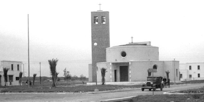
La Chiesa è l’unica a pianta tonda di architettura razionalista, all’interno si trova una magnifica immagine del Cristo Risorto e la dolcissima immagine di Maria Fonte della Vita.
Il nome di Borgo Vodice ricorda il Monte Vodice (652 m) altura simbolo della Grande Guerra situata a nord-est di Gorizia in territorio sloveno, un munitissimo caposaldo austriaco che sbarrava il passaggio dei nostri soldati all’altipiano di Bainsizza nella I Guerra Mondiale.
Il centro abitato di Borgo Vodice ha un aspetto diverso dagli altri borghi, presentandosi più armonico e studiato: la grande piazza, la chiesa e l’acquedotto circolari sono gli elementi che caratterizzano il Borgo.
La parte più alta, immediatamente adiacente all’attuale centro abitato, era percorsa da una ferrovia decauville per il trasporto del legname della macchia che, dall’attuale strada del Parco Nazionale del Circeo raggiungeva il fiume Sisto all’altezza della migliara 54. Da qui il treno percorreva il ponte in legno (poi fatto saltare in area dai tedeschi per allagare le campagne e impedire l’avanzata degli alleati e ricostruito nel dopoguerra) per raggiungere le segherie (località La Sega).

Listen to the audio guide
On 15 June 1934, Engineer Alfredo Pappalardo of the O.N.C. drew up the plan for the building of Borgo Vodice.
The area on which it was built was the one between Lestra Molina delle Capre and Lestra Fontana d’Alma where the waters that did not find a bed in Fosso di Campolungo and Fosso di Campofaiano stagnated.
The first settlers, or appoderati, arrived between the months of October and November 1934, the month dedicated to Christ the King and from which, most likely, the Church and the entire Parish was named.
The Church is the only one with a round plan of rationalist architecture, and inside there is a magnificent image of the Risen Christ and the very sweet image of Mary, the Source of Life.
The name Borgo Vodice is reminiscent of Mount Vodice (652 m), an elevation symbol of the Great War located north-east of Gorizia in Slovenian territory, a fortified Austrian stronghold that barred the passage of our soldiers to the Bainsizza Plateau in World War I.
The built-up area of Borgo Vodice has a different appearance from the other villages, appearing more harmonious and studied: the large square, the church and the circular aqueduct are the elements that characterise the Borgo.
The highest part, immediately adjacent to the present town, was traversed by a decauville railway for the transport of wood from the scrubland, which, from the present road of the Circeo National Park, reached the Sisto River at Mile 54. From here the train crossed the wooden bridge (later blown up in the area by the Germans to flood the countryside and prevent the advance of the Allies and rebuilt after the war) to reach the sawmills (La Sega locality).